A combined GIS-archetype approach to model residential space heating energy: A case study for the Netherlands including validation
Abstract
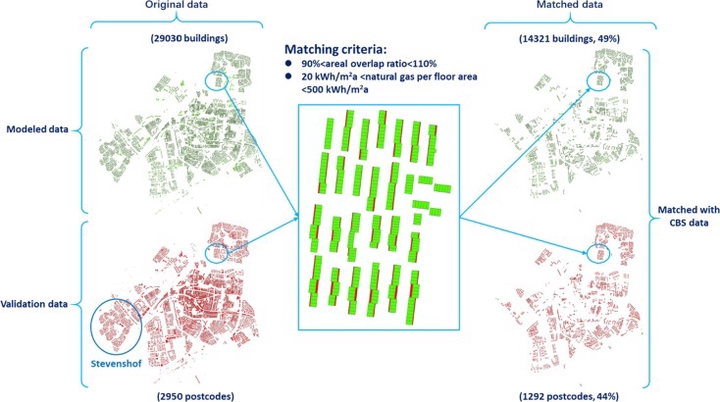
High spatial resolution is critical for a building stock energy model to identify spatial hotspots and provide targeted recommendations for reducing regional energy consumption. However, input uncertainties due to lacking high-resolution spatial data (e.g. building information and occupant behavior) can cause great discrepancies between modeled and actual energy consumption. We present a modeling framework that can act as a blueprint model for most European countries based on geo- referenced data, building archetypes, and public algorithms. Further sophistication is added in a step-wise approach, including the shift from average to hourly weather data, refurbishment, and occupants’ heating schedules. The model is demonstrated for the city of Leiden, the Netherlands, and the simulated results are spatially validated against the measured natural gas consumption reported at postcode level. Results show that when these factors are considered, the model can provide a good estimate of the energy consumption at the city scale (overestimated by 6%). At postcode level, nearly 83% of the absolute differences between modeled and measured natural gas consumption are within one standard deviation (±25 kWh/m2a, about 30% of the mean measured natural gas consumption). Further research and data would be required to provide reliable results at the level of individual buildings, e.g. information on refurbishment and occupant behavior. The model is well suited to identify spatial hotspots of residential energy consumption and could thus provide a practical basis (e.g. maps) for targeted measures to mitigate climate change.